
|

|

|
|
|
|
|

| PLACES TO VISIT |
|
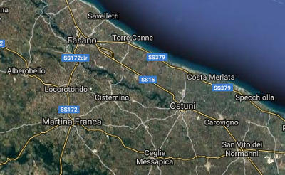
| ITRIA VALLEY |
|
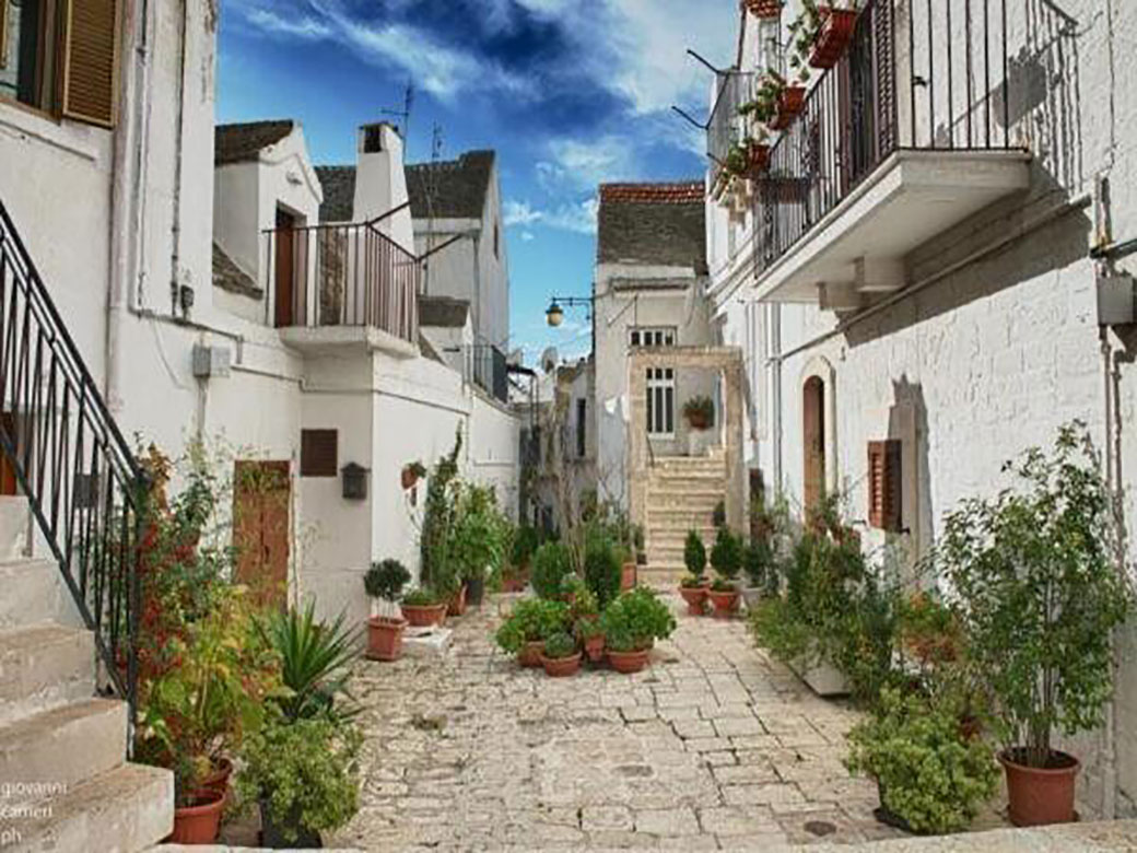
The Itria Valley, also known as the Valley of the Trulli, stretches across the provinces of Bari, Brindisi, and Taranto, encompassing the towns of Alberobello, Carovigno, Castellana Grotte, Ceglie Messapica,
Cisternino, Fasano, Locorotondo, Martina Franca, Noci, Ostuni, Putignano, San Michele Salentino,
San Vito dei Normanni e Villa Castelli. The Itria Valley is a land of countryside inhabited all year round, adorned with the characteristic "Trulli" and dry-stone walls that outline vast expanses of vineyards and olive groves. |
| COASTAL CITIES |
| Along the Adriatic coast of Puglia and in the Terra di Bari, the towns of Monopoli and Polignano have gained significant tourist relevance and fame in recent years. They boast a rugged coastline with enchanting coves and pristine beaches, prestigious and important tourism facilities, as well as an excellent Apulian gastronomic tradition to welcome guests from all over the world. |
| HISTORICAL AND CULTURAL CITIES |
| A stay at "Trullo Giuditta" offers the opportunity to visit urban centers of historical, cultural, and artistic significance such as: Bari, Lecce e Matera, The streets of their historic centers are rich in civil and religious architectural landmarks that narrate their millennia-old history. Visitors can also enjoy the local food and wine traditions, renowned worldwide for their ancient heritage and exquisite flavors. |
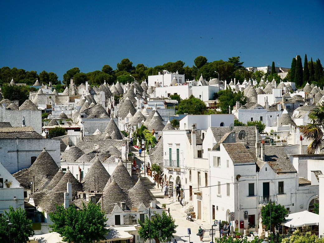
ALBEROBELLO
|
|
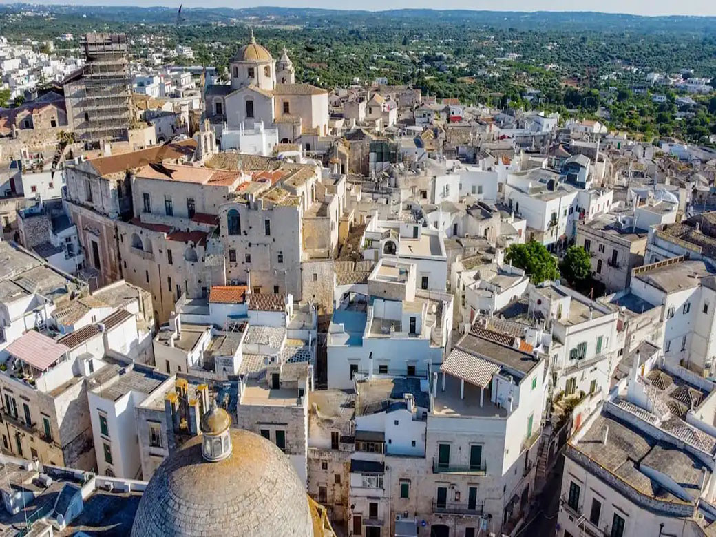
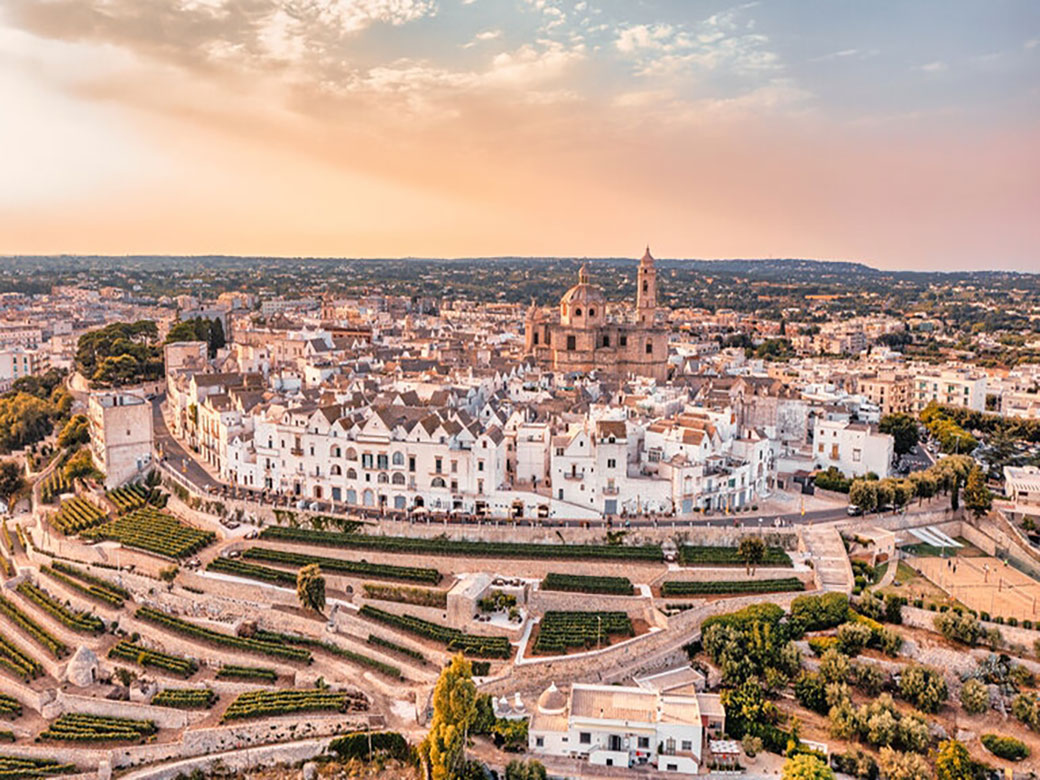
Alberobello is a town famous for its characteristic "Trulli",
a unique form of spontaneous architecture consisting of dry-stone buildings with overlapping stones, a whitewashed base, and a distinctive conical roof adorned with symbols and pinnacles of various shapes.
Alberobello is home to a village of more than a thousand trulli, which were declared a UNESCO World Heritage Site on December 6, 1996. Read on...What to visit in Alberobello: Rione Monti, The largest and most famous trulli district, located on the southern side of the town, with around a thousand trulli cones; Rione Aia piccola, a residential area near Rione Monti, featuring about 400 trulli, exclusively used as homes; Casa Pezzolla, a complex of 15 interconnected trulli, now serving as the Museum of the Territory; Casa D'Amore, first municipal building of Alberobello; Trullo Sovrano a house-museum and the only two-story trullo in the city of Alberobello. |
|
CAROVIGNO
|
|
Carovigno is an agricultural park in the heart of the ancient olive tree route, renowned for its strong tradition as a center of Apulian gastronomy.Read on...What to visit in Carovigno: Castello Dentice di Frasso A majestic castle located near the town’s historic center, perched on a promontory overlooking the entire coastal area. The castle also houses the municipal library and the Museum of Popular Traditions.Torre Guaceto, A protected marine area stretching over approximately 8 km of coastline, featuring wetlands, dense Mediterranean scrub, small coves, and sand dunes. Torre Guaceto is a hub for activities such as cycling tours, hiking, seawatching, and serves as a natural stage for theatrical and musical performances, including nighttime events during the summer season. |
|
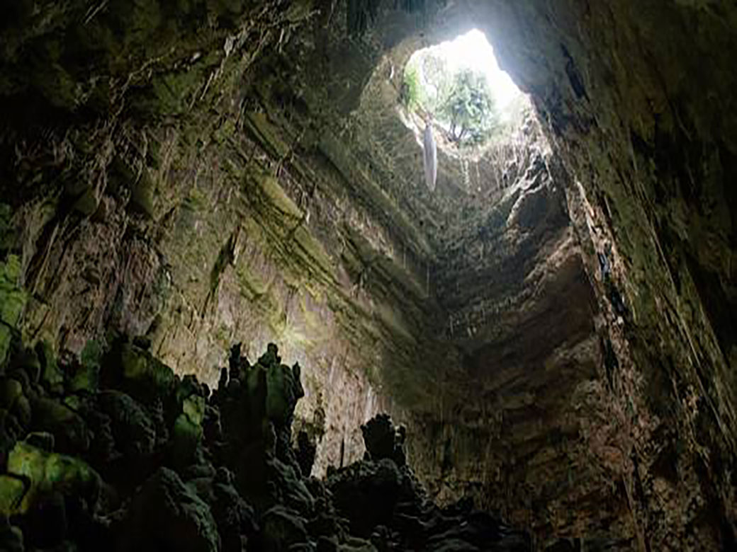
CASTELLANA GROTTE
|
|
Castellana Grotte is a town located on the limestone plateau of the "Land of Trulli and Caves", best known for the karst complex of the Castellana Caves.Read on ...What to visit in Castellana Grotte: Castellana Caves, a complex of underground karstic cavities of great speleological and tourist interest. They extend for about 3 kilometers with a steep descent into the depths of the earth. ."Franco Anelli" Speleological Museum, opened on January 23, 2000, on the 62nd anniversary of the cave system’s discovery, this museum is dedicated to the speleologist Franco Anelli (1899-1977), who discovered, studied, and directed the Castellana Caves. Dinosaur Park, A prehistoric-themed park that recreates an ancient environment, featuring a stunning open-air museum with life-sized dinosaur replicas, faithfully reconstructed from fossils discovered by paleontologists worldwide since 1820. |
|
CEGLIE MESSAPICA
|
|
Ceglie Messapicais one of the oldest towns in Apulia, founded by the Messapians, an ancient Italic people.
This charming village has deep roots in Messapian civilization and boasts a rich architectural heritage along with an exquisite culinary tradition. Read on ...What to visit in Ceglie Messapica: Castello Ducale, A Norman fortress that dominates the town, built around the medieval Norman Tower. Today, it houses a public library. Chiesa Matrice, A church dedicated to St. John the Baptist, built in the 12th century. It features a Romanesque-Puglian style with Byzantine influences. "Emilio Notte" Municipal Art Gallery in Ceglie Messapica dedicated to the Venetian-born futurist painter Emilio Notte. Masseria Fragnite an agricultural estate established between the late 17th and early 18th centuries by the ducal house of Sisto y Britto. It was later sold to the Dominican friars of Ceglie in 1744. Today, Masseria Fragnite is a special place to experience the finest local culinary traditions. |
|
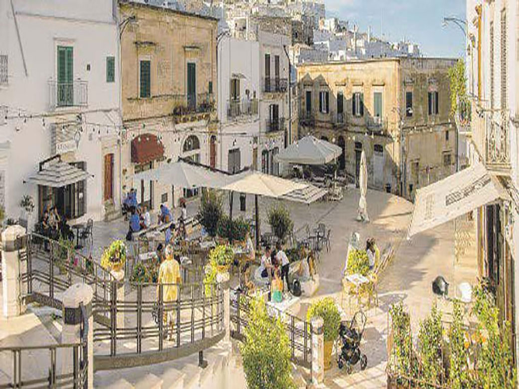
CISTERNINO
|
|
Cisternino is part of the prestigious
"Most Beautiful Villages of Italy"
club and has medieval origins, evident in its urban layout, particularly in the historic center.Read on ...The town was destroyed by the Goths and later rebuilt by the Basilian monks, who established an abbey around which the village developed.What to Visit in Cisternino: Piazza Vittorio Emanuele, The main square of Cisternino, surrounded by restaurants serving traditional cuisine. Also known as "Piazza dell'Orologio" due to the presence of the Clock Tower, built in 1850 using local stone and designed by the Curri masters from Alberobello. Torre Grande one of Cisternino’s symbols, this Norman-Swabian civic tower was built between the 11th and 12th centuries for defensive purposes. Church of San Nicola di Patara The main church of Cisternino, with medieval origins. Its neoclassical façade, added in 1848, houses an important Renaissance sculpture from 1517, the "Madonna con Bambino e Offerenti", also known as the "Madonna del Cardellino". Maaac (Museum of Archaeological Area and Contemporary Art) A recently inaugurated museum in the historic center, located within the complex of San Nicola di Patara Church and the Norman-Swabian Tower. It hosts temporary exhibitions and events focused on contemporary art. Church of San Quirico Martyr built in the early 1600s, this church is dedicated to Saint Quirico, who, according to legend, miraculously freed Cisternino from the plague that devastated Apulia in the 17th century. Church of Santa Maria in Costantinopoli located just outside the town walls, also known as the Church of Saint Anne. A Bourbon decree in 1840 designated it as the city’s cemetery. Palazzo Lagravinese, a noble residence from the late 18th century, once owned by the Lagravinese-Termetrio families, now converted into a museum. Ponte della Madonnina, One of the most scenic viewpoints near the historic center (via San Quirico, close to the Norman-Swabian Tower), offering a breathtaking view of the Itria Valley. |
|
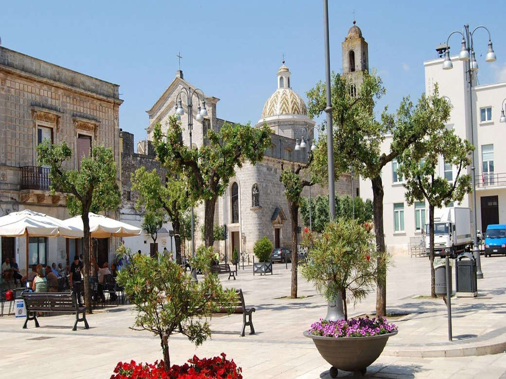
FASANO
|
|
Fasano is a coastal town stretching for approximately 15 km along the Adriatic Sea while also extending inland into the Itria Valley.Read on ...Its origins trace back to the "Casale di Santa Maria di Fajano" (Sancta Maria de Fajano), founded in 1088 by settlers who abandoned the ruins of Egnazia, one of the most important ancient Roman cities along the Via Traiana.What to visit in the historic center of Fasano: Piazza Ciaia the beating heart of Fasano Before the construction of Piazza Maggiore, what would later become Piazza Ignazio Ciaia, the city heart was represented by Largo Seggio and Palazzo Goffredi. Municipal Palace and the Clock Tower stand out among the numerous buildings that characterize Piazza Ciaia. Corso Vittorio Emanuele The city's main street, lined with elegant bourgeois and noble palaces, contrasting with the traditional houses called “alla fasanese”“alla fasanese”(Museo "Casa alla Fasanese"). The historic center is rich in sacred art and churches, including: Chiesa Matrice, L’oratorio di San Giuseppe, Chiesa del Purgatorio, Chiesa di Sant'Antonio Abate, Chiesa di Santa Maria dell'Arco, Corte dei Portici delle Teresiane at number 7 there is "fresco room". Finally, the signs of the city's Renaissance history can be recognized in an imposing fifteenth-century building, erected at the time for military purposes in the southern part of Fasano: Torrione delle Fogge. What to Visit in the "Lands of Fasano": along the Adriatic coast of Fasano we come across the ruins of Egnazia, one of the most important centers in Roman times located on the ancient via Traiana with its port, which was mainly used to reach the beginning of the Via Egnatia (or Via Ignazia), the ancient communication road of the Roman Republic that connected the Adriatic with the Aegean and the Black Sea. Along the Adriatic coast south of Fasano there is a protected natural oasis for about 1000 hectares, recognized as a Regional Natural Park for its precious natural habitats of biodiversity, which extends from the town of Torre Canne to Torre San Leonardo: Il Natural Park of the Coastal Dunes. Towards the north on the Adriatic coast of Fasano, there is the small and pretty seaside village of Savelletri to explore. Center nestled in a wonderful strip of land, between the nearby village of Torre Canne and ancient Egnazia. Prestigious point of reference for enjoying the typical land and sea gastronomy of the area. In the hilly hinterland of the Terre di Fasano, you go up towards Selva di Fasano: hill with Mediterranean scrub of extraordinary biodiversity. In addition, you can have the opportunity to visit ZooSafari: a natural oasis that welcomes and preserves, in complete freedom, animals of all species. With its 140 hectares of extension, it is the kingdom of biodiversity. Continuing inland to the west of the Terre di Fasano, you come across a karst depression, a canal about 12 kilometres long and between 500 and 1500 metres wide, a natural environment rich in extraordinary native vegetation: Canale di Pirro. Going south-east you come across: Borgo di Cocolicchio, a historic village with a high concentration of traditional "trulli"; Laureto di Fasano, A hilltop town offering panoramic views from 400 meters above sea level down to the crystal-clear Adriatic coast of "Terre di Fasano". Continuing immediately south-east of Fasano (along the SS16) you come across: Pezze di Greco, the most populated hamlet of Fasano and known for its living nativity scene; Pozzo Faceto, hamlet of Fasano called Borgo della Madonna del Pozzo, whose name derives from the homonymous sanctuary dedicated to the Blessed Virgin of the Well; Speziale, peaceful hamlet known for its gastronomy and natural beauty. Finally, on the route in the Lands of Fasano, it is noteworthy: Montalbano di Fasano, one of the small villages of Fasano immersed in a landscape of ancient olive trees and uncontaminated countryside, characteristic of this part of the Itria Valley. Among the Montalbano countryside, dotted with monumental fortified farmhouses, you come across an ancient "Dolmen" , a megalithic monument and sacred place for the ancient populations who built it during the Neolithic. |
|
LOCOROTONDO
|
|
Locorotondo
is a village founded between the 9th and 7th centuries BC. The name "Locorotondo" was officially attributed to the hilltop village in the Itria Valley only in 1834.Read on ...Initially, it was called "Casale San Giorgio" in honor of its patron saint, then *Casale Rotondo*, and later "Luogorotondo". The name "Locorotondo" comes from the late latin *Locus Rutundus*, meaning "round place," a reference to the village’s circular urban layout. Encircled by ancient walls, the settlement expands towards the top of the hill, taking on its characteristic round shape. Locorotondo is composed of over 150 "contrade", small hamlets, and rural communities that have developed over the centuries around *trulli*, *masserie* (traditional farmhouses), churches, wells, and courtyards scattered throughout the surrounding countryside.What to Visit in Locorotondo: The historic center is arranged in a circular plan with concentric rings of narrow, whitewashed streets and characteristic alleys. It is known for its typical houses called "cummerse", which feature sloping roofs covered with limestone slabs known as "chiancarelle".The historic center in Locorotondo begins at Piazza Vittorio Emanuele and, passing through the two grand pillars of Porta Napoli, visitors can follow a route that winds through the main points of interest inside the ancient walls. Palazzo Morelli, in the heart of the historic center, it is a historic Baroque style building, built in the 18th century, it stands imposing with its white facade and characteristic dome. The Municipal Palace and the Civic Tower represent one of the most important symbols of the city and an important testimony of its history and culture. Located in the historic center, these two historic buildings are an example of medieval and Renaissance civil architecture. Mother Church of Sangiorgio Martire, a masterpiece of Apulian Baroque architecture built between 1790 and 1825, and Church of Madonna della Greca, first documented in 1520, first documented in 1520, and other notable churches dedicated to saints ( Church of San Rocco, 1710; Church of Maria Addolorata, 1728; Church of Santa Maria Annunziata, 1813; Minor Basilica of dei Santi Cosma e Damiano and Madonna della Catena, 1866; Church of Sant'Antonio da Padova, 1697; Church of San Nicola di Bari, 1582; Church of Beata Vergine Maria del Soccorso, 1642). These sacred buildings reflect the deep religious devotion of the local population throughout history. "Belvedere Santa Maria della Greca", located on Via Nardelli (popularly known as the "Lungomare) offers a spectacular panoramic view over the "Itria Valley". From this viewpoint, visitors can admire the Itria Valley’s signature landscape, dotted with its characteristic buildings: "Trulli" and "Masserie". The "Trulli of the Itria Valley" are unique conical stone structures, historically used as rural dwellings by farmers. Many of them have been restored and converted into prestigious private homes or exclusive tourist accommodations. Trullo"Marziolla" is the oldest documented trullo in the entire Valle d'Itria and dates back to 1559 as reported on the entrance door of the trullo. The "Masserie", scattered throughout the countryside of the Itria Valley, are ancient stone farmhouses—some even resembling small fortified towns. These structures are a testament to the region's deep agricultural roots and millennia-old history. Today, many "masserie" serve as private residences or tourist lodgings, offering an authentic and immersive experience of apulian culture and traditions. Locorotondo also preserves an ancient apulian food and wine tradition. One of its most noteworthy institutions is the Locorotondo Wine Cooperative founded in the 1930s by a group of local farmers and one of Italy’s oldest. This cooperative produces Locorotondo Doc, one prestigious wine known throughout the world. |
|
MARTINA FRANCA
|
|
Martina Franca is a picturesque village nestled in the lush Mediterranean vegetation of the Itria Valley.Read on ...The name "Martina" originates from the inhabitants' devotion to Saint Martin of Tours, while "Franca" was added in the 14th century when the city was granted municipal status by Philip I of Anjou. The historic center of the town sits atop "Monte di San Martino", at an altitude of 400 meters. The 18th century marked a period of significant urban and architectural development, with the construction of buildings, monuments, and churches in a distinctive baroque style known as "Martinese Baroque".What to visit in Martina Franca: historic center is a maze of narrow streets lined with tall houses. In the past, the ground floors of these homes were used as workshops, while the first and second floors were reserved for family life. . At the heart of the town is "Piazza del Plebiscito", where you’ll find the "Basilica of San Martino": built in the second half of the 18th century under the initiative of Archpriest Isidoro Chirulli, it is the finest example of the splendid baroque style of Martina Franca. The church also houses the relics of "Saint Comasia" and "Saint Martina". The town’s deep religious heritage is reflected in its many churches in Martina Franca expression of 18th century baroque architecture, are particularly noteworthy: Church of Beata Vergine del Carmine, Church of Sant’Antonio da Padova, Church of San Vito, one of the oldest religious structures, likely built between the late 13th and early 14th centuries. A short distance away and still in the historic centre of Martina Franca, it is possible to visit, inside the Palazzo Stabile (an 18th-century building): il MuBa – Museum of the Basilica di San Martino. In "Piazza Roma", within the historic center, stands the Palazzo Ducale: an imposing structure dating back to the second half of the "17th century" and a prime example of refined Martinese Baroque style. Palazzo Ducale houses inside Museum of the Pianelle established in 1999 to promote scientific knowledge about the rich biodiversity of the "Bosco delle Pianelle" Nature Reserve.. Palazzo Ducale, also, houses inside Filippo I d'Angiò Museum, which showcases contemporary artworks inspired by the Martina Franca territory. Beyond the Palazzo Ducale, Martina Franca’s historic center boasts an array of magnificent noble palaces, including: Palazzo Martucci in Rome Square; Palazzo Barnaba(1719);Palazzo del cavalier Semeraro(1733); Palazzo Delfini(1776); Palazzo Ancona, considered one of the most beautiful palaces in Martina Franca; Palazzo Carucci(1777); Palazzo Magli(1759); Palazzo Marinosci(1744); Casa a corte Le Marangi (1735); Ex-ospedaletto(1783); Palazzo dell'Università(1759-1762), once the seat of the local parliament; Palazzo Motolese(1775); Palazzo Torricella(1749). One of the oldest palaces in town is "Palazzo Turnone", dating back to the Angevin period. Its imposing structure reflects the power once held by the homonymous family over the city. Today, it houses the "Conservatory of Santa Maria della Misericordia". The region surrounding Martina Franca has "ancient historical origins" and is home to the fascinating Grotta Fellone, which was inhabited during the "Middle Neolithic" period and sporadically during the "Bronze Age". |
|
NOCI
|
|
Noci
is a town built on a hill in the so-called "Murgia of Trulli", a region characterized by its traditional rural architecture, including "trulli" and "masserie".
The town of Noci is part of the "mountain community of Murgia Barese South-East", due to its elevation (~400 meters above sea level), which is higher than that of the neighboring municipalities.Read on ...The earliest records of the town’s origins date back to the second half of the 6th century, when a military settlement was believed to have been established on the hill where Noci now stands. In the late 11th century, the Norman rulers of the Terra di Bari founded an actual town, built around a Norman tower, which was later transformed into a bell tower. The Norman origins and the development of the village in the feudal age are witnessed by the typical medieval urban structure of the historic center, characterized by the presence of gnostre, cloisters, small open spaces closed on three sides and with the fourth overlooking the main road.What to visit in Noci: historic center is distinguished by the presence of "Gnostre", small open courtyards along the town's narrow streets. These "gnostre" originally functioned as streets but were gradually enclosed by buildings as the population grew. Today, these charming enclosed spaces are one of Noci’s most renowned and appreciated attractions for visitors. A prominent municipal symbol since the 19th century is the Torre dell'Orologio, , which rises in the historic center. Nearby, you can admire the Chiesa Matrice di Santa Maria della Natività, built in the early 14th century by order of prince Philip I of Anjou of Taranto. The church boasts a late Gothic façade and a bell tower, while inside, visitors can admire remarkable artworks, including a colorful 14th-century baptismal font. The religious devotion of the local community is also evident in **numerous churches and monasteries**, both in and around Noci, including: Church of Santa Maria di Barsento, according to legend, this church was built for the monks of Saint Equitius by Pope Gregory the Great in 591 , near the site of an ancient settlement. It is perched atop a hill (440 m above sea level) overlooking the canale di Pirro , about 6 km from Noci ; Church of Cappuccini, Located in the town center, this church was originally part of a 16th-century Franciscan convent and underwent modifications between the 18th and 19th centuries; benedictine monastery of Madonna della Scala, situated 5 km from Noci, this monastery offers a panoramic view from its hilltop location. It was built in 1930 on the site of an earlier benedictine monastery. Lastly we have to mention: Santuario della Madonna della Croce, this **15th-century** sanctuary is located just 1 km from the town center and houses a fresco of the Madonna della Croce, created by an unknown artist in the same period. Noci hosts numerous sacred events: the procession of the Mysteries and of the Christ of Casaboli, on the occasion of Holy Week; the Patronal Feast (April 30 – May 4) in honor of "Madonna della Croce"; the feast for San Rocco sees the celebration of the liturgical event on 16 August, followed, on the first Sunday of September, by the fair of the same name full of events and initiatives. On second Sunday of October, the solemn feast of Maria SS.ma del Rosario and Saints Cosmas and Damian, featuring band concerts, fireworks, and light displays. In addition to its religious traditions, Noci is known for its autumn festivals, especially its gastronomic events. The most famous is: Bacco nelle gnostre, a wine and chestnut festival held in the "gnostre", where locals and tourists gather to enjoy a glass of new wine and roasted chestnuts in the charming courtyards of the historic center. |
|
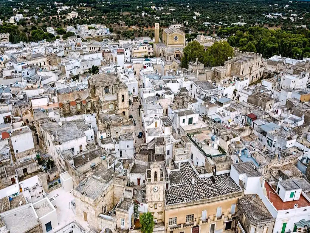
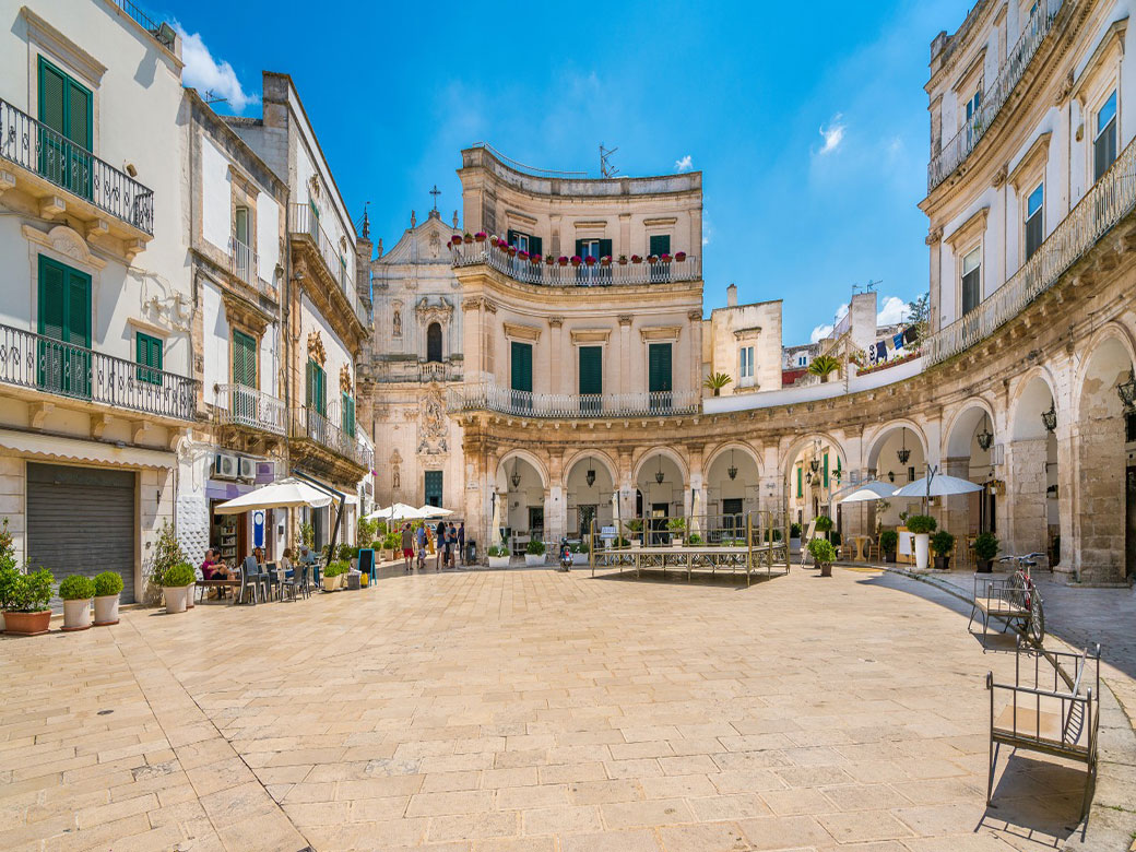
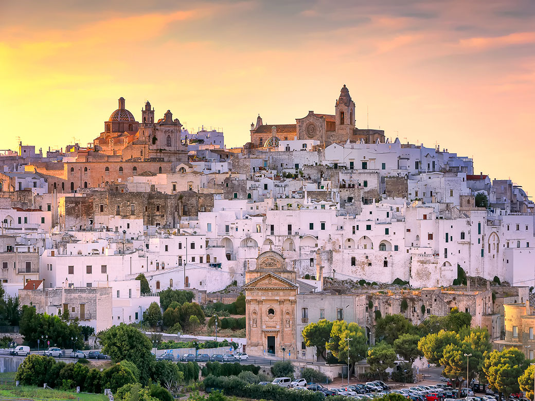
OSTUNI
|
|
Ostuni
rises on three hills on the last foothills of the southern Murgia. The old town of Ostuni, otherwise known as "La Terra," consists of houses painted with lime, which, together with its unique position perched on the hills, have earned it the nickname "The White City".Read on ...The origins of Ostuni are lost in the mists of time. The territory of Ostuni was already inhabited during the Middle Paleolithic (50,000-40,000 years ago). In fact, the hilly area on which Ostuni stands is home to numerous caves, which served as natural shelters for primitive human communities.What to visit in Ostuni: historic center is characterized by completely white houses, painted with lime, among which winding alleys meander, many of which end in dead-end streets. The only real street is the so-called "Via Cattedrale," which divides the entire historic center of Ostuni into two parts. At the end of this street, visitors can admire theArco Scoppa and the imposing Cathedral of Ostuni. Finally, descending the staircase that leads directly to the oldest and most characteristic views of the city, one reaches the Aragonese walls of Ostuni, which encircle the old town and are reinforced with circular towers. To the east of"mura aragonesi" is the Porta di San Demetrio (15th century), while on the western side stands Porta Nova (15th century). From this part of the city, visitors can enjoy a perfect view of the landscape surrounding Ostuni, characterized by lush olive groves framed by the crystal-clear sea. Piazza della Libertà, located in the historic center, serves a dual role it is both a popular tourist spot, thanks to the presence of numerous bars and restaurants, and an important cultural center of Ostuni, home to significant buildings such as: Palazzo di città (formerly a Franciscan monastery); Church of San Francesco d'Assisi (built in 1304 in Gothic style); Church of the Holy Spirit (dating back to the early 1600s) and Obelisk of Saint Oronzo, a symbolic monument of Ostuni (erected around 1771 by Giuseppe Greco, standing approximately 21 meters high and commonly known as "La Guglia"). The old town also hosts historic Noble Residences that offer insight into Ostuni’s characteristic urban structure: Palazzo ducale Zevallos, built in typical baroque style; Palazzo Siccoda, dating back to 1575; the buildings of the Bishop's Palace and the old Seminary, located in the Cathedral Square and connected by the Arco Scoppa; In Vico Castello, there are remains of the castle, built in 1148 by Goffredo III, Count of Lecce and Ostuni, and demolished in 1559 to make room for the episcopal residence; Throughout the old town, visitors can admire prestigious palaces belonging to historic noble families of Ostuni, such as Aurisicchio, Ayroldi, Bisantizzi, Falghieri, Ghionda, Giovine, Jurleo, Palmieri, Petrarolo, Siccoda, Urselli, and Zaccaria. . The deep religious devotion of the local population is reflected in the numerous churches both within the city walls (Cathedral of Santa Maria Assunta, Church of the Holy Spirit, Church of San Vito Martire) and in peripheral locations (Church of Carmine, Church of Santa Maria della Stella). Of particular historical and archaeological interest are: Civic Museum of Ostuni, inaugurated in 1989 inside the former monastery of Santa Maria Maddalena dei Pazzi, which contains artifacts from the Messapic, medieval, and modern periods, discovered in the areas surrounding Ostuni; Dolmen of Montalbano (locally known as the "Tavola dei Paladini") located in the "Occhio Piccolo" district of Fasano, near the village of Montalbano di Fasano; Torre San Leonardo, an anti-Saracen watchtower in the Pilone area; Medieval Castle of Villanova (13th century) which stands near the sea, overlooking a small harbor. The museum also houses original artifacts from the "Santa Maria D'Agnano Archaeological and Natural Park", which preserves the remains of a Messapic settlement and a sanctuary cave, where archaeologists discovered the remains of the "Pregnant Woman of Ostuni", a young woman who died during childbirth about 25,000 years ago. The countryside around Ostuni is dotted with numerous "masserie", some of which hold historical and architectural significance, shedding light on the social and economic structures of the Itria Valley: Masseria Santa Caterina (16th-19th century); Masseria Lo Spagnulo of medieval origin; Masseria Carestia (1754-1777); Masseria Ottava (12th century); Masseria Cappuccini (17th century); Masseria Ferri (18th century). Ostuni’s coastline is one of the most attractive seaside destinations in Puglia, featuring a wide variety of accommodations to meet different tourism needs. The "Dune costiere" Regional Natural Park is a protected natural area located about ten kilometers from the center of Ostuni. It extends from Torre Canne to Torre San Leonardo, and includes well-known coastal locations such as Pilone, Rosa Marina , Monticelli, Villanova e Costa Merlata. Ostuni hosts religious celebrations religious celebrations throughout the year, including: Feast of San Biagio (February 3) and Feast of Madonna della Nova, held on the Sunday following Easter. Numerous festivals and fairs are organized in the city center, particularly in the summer months of July and August. Notable events include: la "Sagra dei Vecchi Tempi", a festival celebrating traditional foods and crafts, held in the picturesque alleys of the old town during mid-August, and "Cavalcata di S. Oronzo" a historic event that takes place on August 25, 26, and 27. This traditional horseback parade is part of the solemn procession dedicated to Saint Oronzo, the patron saint of Ostuni since the mid-17th century. |
|
PUTIGNANO
|
|
Putignano
rises on three hills in the Murgia region, known for its trulli and caves, within the Itria Valley.Read on ...The origins of Putignano trace back to an ancient Peucetian settlement, as evidenced by numerous archaeological findings. In the absence of additional historical records, it is believed that Putignano flourished during the era of Magna Graecia and later became a Roman municipium. During the Middle Ages, around the year 1000, the territory of Putignano came under the ownership of the Benedictine monks. For more than seven centuries, Putignano was a "nullius", meaning it was directly dependent on the Pope for both spiritual and temporal power, first under the governance of the Benedictines for 200 years and later under the Knights of Malta until 1808.What to visit in Putignano: the historic center of Putignano has an elliptical shape, once protected by massive walls (now gone) and a wide moat, which in the 19th century was transformed into a broad outer ring road. The old town is a labyrinth of narrow and winding streets leading to an elegant array of historic palaces surrounding Piazza Plebiscito , where visitors can admire Palazzo del Balì, formerly the residence of the Knights of Malta and now home to the Civic Museum; the dedicated to Saint Peter the Apostle and “Sedile”, the historical seat of the municipal government until 1835. Historically, access to the historic center of Putignano along the ancient walls was allowed through three main gates: "Porta Barsento", facing toward Alberobello; "Porta Nuova", leading toward Castellana Grotte; "Porta Grande", the main entrance gate to the old town in direction of Noci-Gioia del Colle. Putignano's historic center is dotted with numerous churches, reflecting the strong religious devotion of its inhabitants. Notable among them are: Church of Saint Peter the Apostle (11th century), Church of Santa Maria La Greca (12th century), Monastery Church of Santa Chiara (16th century), Church of Santi Medici Cosma e Damiano (16th century), Church of San Lorenzo or Visitazione di Maria medieval period, Church of Santo Stefano Piccolo (15th century), Church of Santa Maria di Costantinopoli(16th century), Church of Maddalena (18th century), Church of San Domenico (17th century), Convent of Cappuccini (17th century), Church of Madonna del Carmine (17th century). Additionally, several rock-hewn churches were built near the city center: Cave of San Michele in Monte Laureto(6th century), Rock Church of Madonna delle Grazie (16th century), Church of San Biagio (20th century). Putignano is an **ideal destination for exploring the karst landscape** that characterizes much of Puglia. There are around thirty significant caves within the municipal territory, valuable for both cultural and scientific reasons. For instance, the Cave of Saint Michael has long been a place of worship, while some caves have revealed rare species of cave-dwelling fauna. The most famous and visited cave in Putignano is the Grotta del Trullo; discovered on June 26, 1931, during excavation works. This discovery marked the beginning of systematic exploration and research into the underground world of the entire region. The "Putignano Carnival" is the oldest and most famous event in the city. In fact, it is the oldest Carnival in Europe and one of the longest in the world, starting on December 26 (Saint Stephen’s Day) with the traditional "Propaggini". Farinella is the iconic mask of the Putignano Carnival. Like the rest of Puglia, Putignano offers a rich gastronomic tradition, featuring a variety of local dishes (orecchiette with turnip greens, fava bean purée with chicory, wheat with olive oil and cheese, bread patties, classic or donkey braciole e agnello con patate)served in its many restaurants and trattorias. |
|
SAN MICHELE SALENTINO
|
|
San Michele Salentino
is located in a region that has been inhabited since prehistoric times.Read on ...Evidence confirms the presence of Neanderthal man (Middle Paleolithic period, 185,000-35,000 BC) in the cave at Contrada Augelluzzi, where nearby, remains of a Bronze Age hut village (between the 9th and 7th centuries BC) have also been discovered. The origins of San Michele Salentino date back to the early 17th century, when the Count of Mola and Baron of San Donato established a small village around a pre-existing "masseria" and populated it with ninety families of emigrants from Schiavonia, a region of the Balkan Peninsula. This origin explains why, until a few decades ago, San Michele Salentino was known as "Masserianova". From the mid-18th century, the fate of San Michele Salentino became closely linked to the larger nearby town of Ceglie Messapica. With the abolition of feudalism during the Napoleonic era in 19th century, San Michele Salentino was annexed to the municipality of San Vito degli Schiavoni, now called San Vito dei Normanni. By 1912, as the population grew, the residents of San Michele Salentino expressed their desire to become independent from San Vito dei Normanni. Their wish was granted on October 2, 1928, when King Victor Emmanuel III issued a Royal Decree officially elevating San Michele Salentino to the status of an independent municipality.What to visit in San Michele Salentino: in the historic center of San Michele Salentino, visitors can explore the "Salvatore Cavallo" Art Gallery, founded in the 1980s and located near the Municipal Villa and Town Hall. It houses a rich monographic collection dedicated to the local artist Stefano Cavallo. In Piazza Dante you come across the Chiesa Madre, built between 1876 and 1882, which features two marble plaques on its facade, commemorating important moments in the town’s foundation; and not far away, the Church of San Michele Arcangelo (built in 1935) showcasing a Neoclassical architectural style at the heart of the historic center. In the rural areas surrounding San Michele Salentino, visitors can find typical masserie which reflect the region’s traditional agricultural and culinary heritage: Masseria Augelluzzi, in contrada Augelluzzi, where visitors can witness the traditional cheese-making process; Masseria Cotugni and Masseria Archinuovi two historical rural settlements that once played a key role in local agricultural production but are now unfortunately in a state of abandonment. Also in Contrada Augelluzzi, visitors can explore the Augelluzzi Natural Park, which offers guided hikes through a landscape rich in Mediterranean flora and fauna. Toward the end of summer, San Michele Salentino hosts the "Festival of Fico Mandorlato", a celebration of one of the region’s most prized products. This traditional fig-based delicacy, recognized as an official Traditional Agri-Food Product by the Ministry of Agricultural Policies, is a highlight of the local gastronomy. |
|
SAN VITO DEI NORMANNI
|
|
San Vito dei Normanni
is located in the northeastern part of the Salento plain, a land rich in centuries-old oak and olive trees, where the characteristic dry-stone walls divide the agricultural properties. The town lies within the Itria Valley and is just a short distance from the most famous beaches and coastal areas of the Adriatic Sea.Read on ...The prehistoric origins of San Vito dei Normanni are debated. Human presence during the Bronze Age is suggested by the discovery of thirty burial sites and various ceramics dating back to 1800-1700 BC in the Mondescine area. Additionally, more recent excavations have uncovered prehistoric settlements (18th-4th century BC) in the Contrade Castello and Paretone. The earliest official document attesting to the town’s existence dates back to the medieval period: a parchment from 1180, which mentions San Vito alongside Ostuni and Carovigno. By the late 10th century, a colony of Slavs (Schiavoni) had settled in the area known as "Castri Sancti Viti". Over the centuries, the town has had various names, including San Vito degli Schiavi or San Vito degli Schiavoni and San Vito in Terra d’Otranto. Its current name, San Vito dei Normanni, was officially adopted on December 13, 1863, by Royal Decree. Later, on April 14, 1994, a Presidential Decree granted the town the official status of a city.What to visit in San Vito dei Normanni: the historic center of San Vito dei Normanni is a maze of narrow alleys and streets lined with low, old houses, ancient palaces, and Baroque churches. It still retains its medieval urban layout, developing concentrically around the historic "Castello Dentice di Frasso". Over the centuries, the castle has changed hands multiple times and eventually became the residence of the Dentice di Frasso family, whose descendants still own it today. One of the most distinctive landmarks in the historic center is the "Torre Quadrata", a medieval military tower built in the 11th century, serving as a clear example of medieval defensive architecture. The center of San Vito dei Normanni is full of testimony to the religious vocation of the local population: Church of Santa Maria della Vittoria, o built in memory of the Battle of Lepanto (1571), although later modified by 18th-century restorations; Church of San Giovanni Evangelista (15th century); Church of Santa Maria della Mercede (18th century); Church of Santa Maria delle Grazie , also called "Il Convento" (16th century); Church of Annunziata, also known as Church of San Domenico (16th century); Church of San Michele Arcangelo (20th century); Church of Santa Maria della Pietà, also known as Church of the Hospital (16th century); Church of Santa Rita (20th century); Church of Santa Teresa (19th century). The San Vito territory is also home to numerous rock-hewn settlements, created by Byzantine monks fleeing from the East who sought refuge in the area. Notable sites include: Cave of San Biagio, Crypt of San Nicola, la Crypt of San Giovanni e la Crypt of Santa Maria di San Giacomo al casale. Near San Vito dei Normanni, visitors can explore several natural and tourist sites, including: Torre Guaceto nature reserve, located on the Adriatic coast, this is one of Puglia’s most beautiful protected areas, covering approximately 1,200 hectares and encompassing both terrestrial and marine zones; Specchiolla, Torre Santa Sabina and Costa Merlata, some of the most picturesque and pristine beaches along the Adriatic coastline. San Vito dei Normanni boasts a rich culinary tradition, with unique traditional dishes, such as: "maranciani chini" (stuffed eggplants), "favi e fogghi" (fava beans with wild greens), "li gnummarieddi" o "turcinieddi" (local meat skewers). San Vito dei Normanni is also renowned for its wine and olive oil production, being part of both the "Strada dell’olio Collina di Brindisi" (Brindisi Hills Olive Oil Route) and of "Strada del vino Appia dei vini" (Appian Wine Route). San Vito dei Normanni hosts several important annual festivals, including: the patronal feast celebrated on June 15th in honor of the town's patron saints, "San Vito" and "San Vincenzo Ferreri"; "Sagra di Ferragosto" on August 15h, where visitors can enjoy local food specialties and experience the "pizzica" dance in the town square. |
|
VILLA CASTELLI
|
|
Villa Castelli
is located in the southwestern part of the Murge plateau, between the Itria Valley and Salento, in a hilly area at the border of the Salento plain.Read on ...The prehistoric origins of Villa Castelli are confirmed by at least three ancient settlements in the area: Monte Scotano, Monte Fellone, Pezza Petrosa, the most well-known. Additionally, the surrounding landscape features numerous "specchie", at the borders between the Messapian and Tarantine territories. Between the 16th and 17th centuries, the area known as Li Castelli" was one of the largest estates in the Francavilla countryside, where the local Imperiali feudal family established a horse breeding farm, which flourished until the late 18th century. By that time, the estate "Li Castelli" came under the rule of the duke of Monteiasi. At the beginning of the **19th century**, the name "Li Castelli" or "Monte Castelli" was changed to **Villa Castelli**, inspired by the French word "ville" (city), similar to Francavilla, of which Villa Castelli was once a district. In 1926, Villa Castelli became an independent municipality. What to visit in Villa Castelli: the historic center of Villa Castelli reflects the traditional atmosphere of Itria Valley towns, with narrow streets leading into small squares, whitewashed houses with colorful shutters, and architectural gems, including churches and noble residences.The "Castle" is oldest medieval tower (13th century) in the town, located in Piazza Municipio. Today, it houses the Town Hall, the Municipal Art Gallery, and the Archaeological Museum. Incorporated into the facade of the town hall we find the "Clock Tower" dating back to the early twentieth century and Throughout the historic center you can see "sundials" of 19th century manufacture, the most famous of which is located in via Fratelli Bandiera. The historic center of Villa Castelli preserves the architectural evidence of the religious faith of the inhabitants: Church of Immacolata built in 1823; Church of San Vincenzo de Paoli, whose construction began in 1898; Church of Crocefisso, the oldest religious structure in the town, built in 1822. The Sanctuary of Calvario located at the foot of Montecalvario, housing a statue of Christ in the sepulchre. Villa Castelli is crossed by a "gravina", which is part of the "Terra delle Gravine Natural Park", designated as a protected area in 2005. Within the gravina, there is an 18th-century "underground olive mill", carved into the natural caves. The gravina is spanned by the "Ponte Vecchio" (Old Bridge), a nine-arch stone bridge built in the 1930s by local craftsmen to connect the town with the expanding Lizzito district. In the countryside around Villa Castelli, there are several small roadside chapels, mostly built between the early 19th and 20th centuries. Villa Castelli is home to numerous masserie, some of which are fortified: "Antoglia" , where a 14th century crenellated tower stands out (Torre dell'Antoglietta), protected by high courtyard walls; "Fallacchia", which retains elements of its 18th-century defensive structures; "Sciaiani Piccola"(18th century); "Puledri"(18th century), named after its historic horse-breeding farm; "Montescotano" near the Monte Scotano hill, with lands documented in 17th-century notarial records from Ceglie Messapica. . Other notable fortified "masserie" include:: "Abate Carlo"; "Carnevale"; "San Barbato"; "Renna"; "Tagliavanti"; "Sant'Eramo"; masseria "Sciaiani Piccola e Grande". The territory surrounding Villa Castelli is of particular historical importance as it is the site of numerous archaeological areas: the Necropolis of "Pezza Petrosa" home to the "Pezza Petrosa Archaeological Museum"; the "room of lamps", located in Monte Scotano ; the necropolis of "Pezza le Monache"; "Cave of Monte Fellone" is in the locality of the same name. Every year, at the beginning of October, Villa Castelli celebrates a festival honoring its patron saints, the "Sacro Cuore di Gesù e la Vergine Santissima della Fontana"; during which the streets of the town are animated by a large city fair. |
|
MONOPOLI
|
|
|
Monopoli
Monopoli is located along the Adriatic coast, 40 kilometers south of Bari, in the geographical area known as the "Terra di Bari". The city of Monopoli is known as the "city of a hundred districts." These districts are characterized by the presence of ancient fortified farmhouses (centers for agricultural activities), churches and rock settlements, trulli, neoclassical patrician villas, and colonial houses. Read on ...The urban structure of Monopoli's historic center, which overlooks the sea and is surrounded by high walls, testifies to its early medieval origin, built on the remains of a fortified Messapian settlement from the 5th century BC. In the second half of the 13th century, the city experienced Angevin rule, followed by Aragonese rule, and later fell under Venetian dominion in 1484. Shortly after, the city passed from Venice to the French. In the 16th century, following peace with Venice, Monopoli peacefully came under the control of Charles V of Habsburg. From the mid-17th century onwards, Monopoli followed the fate of the rest of southern Italy, under Bourbon rule, and was later annexed to the Kingdom of Italy in 1860.What to visit in Monopoli: the historic center of Monopoli extends from the "Borgo", the traditional name given to the central Piazza Vittorio Emanuele, one of the largest in Puglia and Italy (1796). It features streets lined with shops, boutiques, and charming venues leading to the Adriatic coast. From the Borgo, visitors can reach the majestic "Basilica Cattedrale Maria Santissima della Madia", built in the 15th century on the remains of an ancient Romanesque cathedral. Beneath the current cathedral, remains of the crypt of the Romanesque cathedral, along with archaeological findings dating from the 16th century BC to the 18th century AD, are preserved within the archaeological route of the "Museum of the Crypt of Romualdo". Near the port stands the, "Castle of Charles V"built by the sea during Spanish rule to protect the ancient harbor and the "Spanish barracks" constructed at the expense of the citizens in the 16th century to house Spanish soldiers and now serving as a library. Monopoli's coastal defense system was completed at the end of the 16th century with the construction of towers along the shore, including: Torre Cintola , Torre San Giorgio and Torre D'Orta. "Piazza XX Settembre", named after September 20, 1870 ("Breccia di Porta Pia"), serves as the urban link between the "Murattian borough" and the medieval historic center. Archaeological excavations in this square have uncovered the powerful bastion of San Domenico and the entire wall complex that once formed the western fortifications of Monopoli. Monopoli's historic center is home to several noble palaces: Palazzo Palmieri (18th century), featuring over 100 rooms, it stands isolated on the east side of the eponymous square, the oldest in the city; Palazzo Martinelli (18th century) overlooking the old port, characterized by a loggia with eight pointed arches in Neo-Gothic style, supported by three large arches, and a balustraded balcony.. Numerous sacred buildings (churches, convents, and monasteries) testify to the religious devotion of Monopoli's inhabitants throughout history, including: Church and monastery of San Martino (10th century); Church and convent of San Francesco D'Assisi (16th century); Church and convent of San Domenico(10th century); Church and convent of Santa Teresa or Conservatory of the Holy House (17th century); Church and convent of San Giuseppe e Anna (17th century); Church and convent of San Leonardo (18th century); Church and convent of Sant'Antonio da Padova (17th century); Church of San Pietro (4th century); Church of San Salvatore (3rd-4th century); Church of Santa Maria del Suffragio or Nativity of Mary (17th-18th century); Church and convent of San Nicola in Pinna (10th century); Church and convent of San Francesco da Paola (17th century); Church of Santa Maria Amalfitana (17th century). Furthermore, the inside of the urban center of Monopoli is full of archaeological sites of particular interest: the archaeological route of the Cathedral, part of the "Museum of the Crypt of Romualdo", which includes a Bronze Age village (16th century BC), Messapian (5th-3rd century BC) and early Christian (6th-7th century AD) necropolises, and the Crypt of Romualdo (12th century AD), the bishops' burial ground (used from the end of the 18th century AD). Evidence of the history of Monopoli from the 16th century BC to the 13th-18th century AD has been found in the church of Santa Maria Amalfitana. Archaeological remains dating back to various periods of the city's history have emerged beneath numerous monuments and squares in the city centre of Monopoli: excavations under Castello Carlo V, revealing fortifications from the 5th century BC, a Roman gate from the 1st century BC, and various structures from the 10th to the 17th century AD; excavations in Piazza Vittorio Emanuele uncovering a 15th-century medieval cemetery and monastery; at last, revealing 12th-century urban walls and the 16th-century Bastion of San Domenico. The Monopoli countryside is vast and populated, divided into numerous "Contrade": rural districts and each Contrada typically features a church, a farmhouse, or a hamlet with scattered houses. Notable Contrade include Impalata, Santa Lucia, Gorgofreddo, Cozzana, Antonelli, Virbo, San Bartolomeo, Sant'Antonio d'Ascula, and Capitolo. Particular interest, in order to understand the structure and history of the Monopoli countryside, are the "Fortified Masserie", built between 1610 and 1690, presenting a tower as the central nucleus of the "masserie" for defensive purposes. Today it is possible to visit the fortified "masserie" in the Monopoli countryside: Masseria Caramanna (17th century); Masseria Spina Grande (17th century); Masseria Spina Piccola (15th century); Masseria Garrappa (16th century); Masseria Conchia (XVII sec.); Masseria Cavallerizza (15th-16th century); Masseria Petrarolo (17th century). Monopoli countryside also preserves important sacred buildings: Church of Sant'Angelo in Francisto o Frangestro (11th century) and Church of Cristo delle Zolle (17th century). Archaeological sites in the countryside include: Grotta delle Mura, Grotta di Cala Corvino and Grotta di Cala Camicia where prehistoric artifacts have been found. In Contrada Baione, remains of a Roman villa with small thermal baths have been discovered. Parco della via Traiana divided into urban stretch, stretch Torre Cintola, stretch Torre San Giorgio. At last, in "Contrada Tortorella - S.Michele", around the church of Sant'Angelo in Francisto or Frangesto, remains of an early medieval village and a benedictine monastery have emerged. It is important to point out that in the Middle Ages the Monopoli countryside was full of agricultural villages called "casali", from which some of the names of the current "contrade" are derived: the last remains of the large and ancient hamlet of Frangestro coincide with the church of Sant'Angelo in Francisto or San Michele di Frangesto (Ecclesia S.Angeli de Frangestro), currently corresponding to the Loggia di Pilato, in the Tortorella district. Monopoli’s coastline offers breathtaking Mediterranean landscapes, with numerous coves ideal for swimming in crystal-clear waters, such as: Cala porta vecchia, Cala tre buchi, Porto Ghiacciolo and the seaside district of Capitolo, all a few kilometers from the city center of Monopoli. Monopoli’s gastronomy features typical Apulian dishes like "taralli", "focacce", "patate riso e cozze", "panzerotti", "braciole", "olive fritte", "timballi, and seafood specialties, also offers typical Monopoli dishes: "orecchiette" made with durum wheat semolina or "grossetto"; "cjambotto", an assorted fish soup; "ingrapiata", a dish with fava beans and chicory; "polpo in pignatta", stewed octopus; "alici marinate", marinated anchovies, and many other seafood specialties. The rites and celebrations celebrated in the urban centre of Monopoli have an exquisitely religious character: Patronal Feast of Madonna della Madia (August 14-16, December 16); Feast of San Giuseppe (march 19); Annunziata Fair (march 25); Feast of Santi Medici (June 9-10-11); Feast of S.Anna (July 26). Throughout summer and early autumn, the rural districts of Monopoli host food festivals, including the: "Sagra del panzerotto e frittella farcita" (contrada Impalata); "Sagra della vera frittella farcita" (contrada Sicarico); "Sagra del panzerotto" (contrada S.Lucia); "La vallata del folklore" - Food and Wine Tastings (contrada Ciporrelli); "Sagra del panzerotto e della frittella farcita" (Festa di Santa Chiara in contrada Capitolo); Sagra del panzerotto (contrada L'Assunta); Sagra delle orecchiette e frittella farcita (contrada Antonelli); Feast of contrada Cozzana; Feast of contrada Laghezza. |
|
POLIGNANO
|
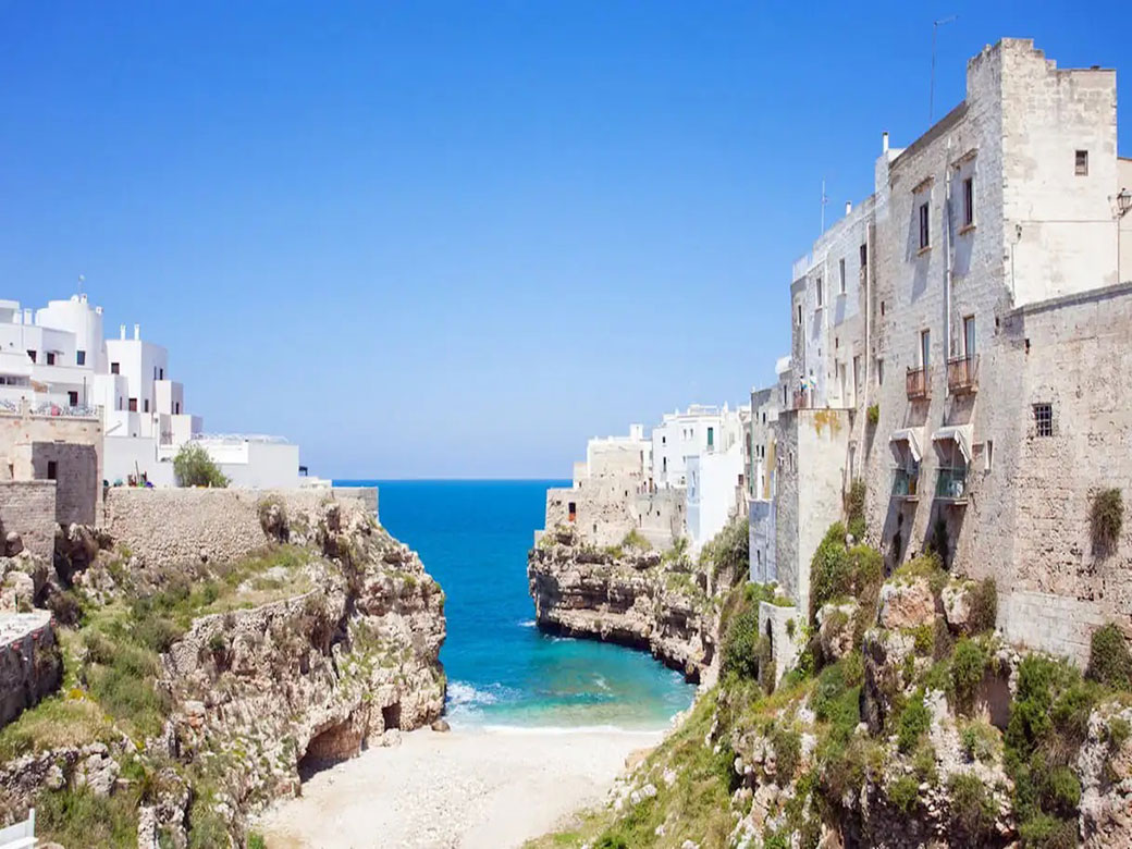
|
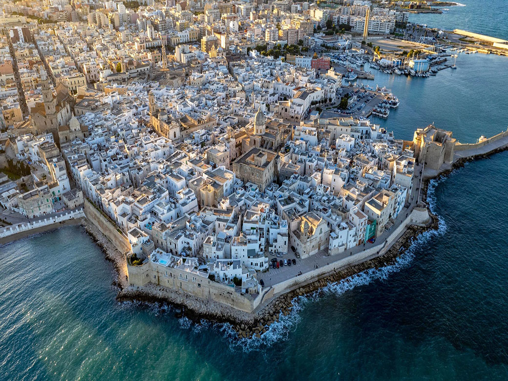
Polignano a Mare
Polignano a Mare is located along the Adriatic coast, 33 kilometers south of Bari, perched on a rocky cliff overlooking the Adriatic Sea.Read on ...Evidence of human presence dating back to the Neolithic period has been found in the area of Santa Barbara (6th–5th millennium BC) and in the Manfredi Hypogeum (4th millennium BC), making it one of the most significant prehistoric settlements in central Puglia. Archaeological investigations have revealed the existence of a Bronze Age village that, thanks to its strategic position and natural harbors, became an important trading port. In ancient times, Polignano was frequented by various populations (Iapygians, Corinthians, and Athenians), eventually becoming a strategic point for the power of Taranto at the beginning of the 3rd century BC. During the early Middle Ages, Polignano fell under the jurisdiction of the Byzantine Empire, adopting the Orthodox religion, before coming under Norman rule until the 12th century. It was later dominated by the Angevins and, in the 16th century, ruled by Venice for twenty years before being ceded to the Spanish Emperor Charles V. Spanish rule continued throughout the 18th century, incorporating Polignano into the Kingdom of the Two Sicilies.What to Visit in Polignano a Mare: the historic center of Polignano is reached by crossing the bridge on Via Traiana which spans the deep inlet just north of the old town, known as, Lama Monachile (or Cala Ponte). Lama Monachile is the chosen location for several editions of the world’s most spectacular diving competition: the "Red Bull Cliff Diving World Series". The entrance to the historic center is marked by the Arco Marchesale, also known as Porta Grande, which, from the 18th century, served as the only access point to the town, protected by a city wall built in the 16th century. Today, above the Arco Marchesale, the remains of the 15th-century Church of San Giuseppe are still visible. Beyond the Arco Marchesale, visitors will find Church Matrice di Polignano, dedicated to the Madonna of Assunta, located in the small Piazza Vittorio Emanuele. Along "Via Giudea", the former Jewish ghetto, stands the Church of Purgatorio in via Mulini, on Via Mulini, where a chapel dedicated to San Martino existed as early as the 15th century. In the old town, you can also visit the Church of Sant'Antonio (16th century) in the square of the same name and the Church of San Cosma e Damiano (19th century), which highlight the deep religious tradition of the local population. In the "San Vito" district, on the northern coast near the small harbor, stands the imposing Abbey of San Vito, a benedictine monastery designed in the 10th century.. Wandering through the narrow streets of the center, visitors arrive at a panoramic terrace that offers breathtaking views of the jagged cliffs and rocky coastline surrounding Polignano, hiding a network of sea caves: "Grotta della Rondinella", "Grotta Palazzese", home to an exclusive restaurant, "Grotta dell’Arcivescovado" and "Grotta delle Monache". From the bourbon bridge of Lama Monachile, visitors can descend to the so-called "Beach of Desires", Polignano’s most famous beach, located in an ancient riverbed that once flowed into the Adriatic. Now dry, it sits within one of the "lame", a type of fjord that cuts through the high cliff walls surrounding the town. On the Polignano seafront, a statue of singer Domenico Modugno, standing three meters tall and created by sculptor Hermann Mejer, celebrates the birth of one of the most illustrious citizens. The area around Polignano preserves important archaeological sites: Santa Barbara site, a Neolithic settlement about 2 km from the town, featuring a karst cave known as Sancta Barbara, which has evidence of human presence dating back to the 4th millennium BC. Madonna di Grottole site, about 3 km from the town, one of Puglia’s oldest archaeological locations. At last, Torre Incina, located in Cala Incina between Polignano and Monopoli, one of the most fascinating coastal watchtowers built in the 16th century during Spanish rule over the Bari region. In the Polignano countryside, as in nearby Monopoli, numerous "masserie" (rural farmsteads) can be found. These historic estates, dating back to the 17th century, served as centers of agricultural and pastoral life. Some of the most notable include: Masseria San Martino, Masseria Basile-Pellegrini, Masseria Bellini, Masseria Bellipario, Masseria Cannone-Baldassarre, Masseria Chiantera-Comes, Masseria Crocifisso, Masseria De Nigris, Masseria La Greca, Masseria Pozzovivo and Masseria Tubiola. Polignano a Mare also offers traditional food and wine specialties from the "Terra di Bari" region in its historic center and local restaurants: raw seafood, "riso, patate e cozze", the famous Polignano carrot ed the unique "caffè speciale",a **local specialty coffee** made with **sweetened espresso, lemon zest, fresh cream, and amaretto**, served in a small glass. Among the religious festivals celebrated in Polignano a Mare, the most important is the Feast of the town’s patron saint San Vito, held annually on June 14th and 15th. |
|
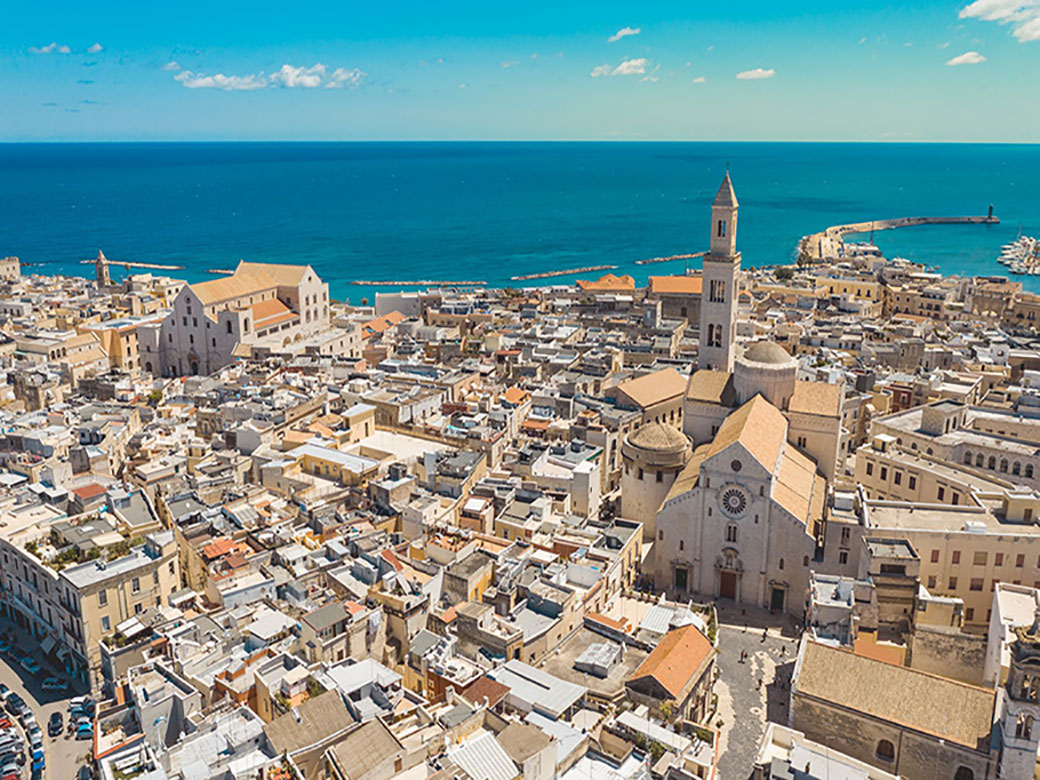
BARI
|
|
Bari
overlooks the Adriatic Sea along a territorial and municipal length of about 40 km. The municipality of Bari is located in the center of a vast flat and depressed area known as the "basin of Bari"; in its central part, it extends a few kilometers inland, reaching the first slopes of the Murge plateau.Read on ...The ancient origins of the city of Bari are evidenced by archaeological remains found in excavations conducted around the Church of San Pietro, in the old city. These findings suggest the existence of an original Bronze Age settlement belonging to the Illyrian Peucetians. In the 3rd century BC, "Barium" came under Roman rule and experienced significant urban development following the construction of the via Traiana. From the 4th century AD, it became an episcopal seat, and after the fall of the Roman Empire, it was under Lombard and later Byzantine rule. In fact, the current layout of the "old city" dates back to this period and was centered around the Catapan court (now the Basilica of San Nicola). Between 847 and 871, Bari was the seat of an emirate under Arab rule, which was later replaced by Lombard rule under the Dukes of Benevento. From 875, Bari returned to Byzantine rule as the capital of the "Theme of Langobardia": a territory comprising Apulia and Calabria. In 1002, the people of Bari, led by the noble Melo of Bari, rebelled against the Byzantine Catapan’s fiscal government, gaining autonomy by 1018. In 1068, the Normans besieged the city and conquered it from the Byzantines in 1071. In 1087, the relics of Saint Nicholas of Myra arrived in Bari.During the Swabian era, under the rule of Frederick II Bari experienced a period of prosperity, with medieval urban development centered around the castle he had built. However, after this period, the city declined under Angevin, Aragonese, and Spanish dominations. In the 16th century, Bari regained some of its former glory under the rule of the Sforza family. In 1556, Princess Bona Sforza d'Aragona settled in Bari, which she had inherited as a principality, and remained there until her death in 1557. In modern times, in 1813, Joachim Murat initiated the city's new urbanization, demolishing the city walls and creating a district at the gates of the old city, which still bears his name: "borgo murattiano". Under the Kingdom of Italy in the 19th century, Bari was designated the capital of the Apulian region, and the 20th century saw exceptional demographic growth and the construction of important public institutions, such as:Piccinni Theater, the Chamber of Commerce, the Apulian Aqueduct, the Petruzzelli Theater, the University of Studies. During the Fascist era, Bari’s waterfront was built, featuring monumental buildings that still house important public institutions and the Fiera del Levante, a major trade fair, was also inaugurated. Bari was one of the main centers of antifascist political activity in Allied-occupied Italy. On January 28-29, 1944, it hosted the Congress of the Provincial Committees for the Liberation of Antifascist Parties. Additionally, since September 1943, Radio Bari became the first radio station of Italy freed from Fascism. What to Visit in Bari: The historic center consists of "Bari vecchia", as locals call it, and the "Borgo murattiano". The old city, located on a rocky peninsula jutting into the sea, represents the original core of Bari with its typical medieval urban layout, characterized by narrow, irregularly arranged streets with two main churches at its center: the "Basilica of San Nicola" and the "Cathedral of San Sabino". The urban structure of Bari Vecchia dates back to the Byzantine rule and houses the city's major monuments, including: Norman-Swabian Castle, Fortino di Sant'Antonio Abate and the long "Muraglia" (12th century) that surrounds the old city. "Bari vecchia" also preserves artifacts and relics from indigenous Apulian civilizations (Daunians, Messapians, and Peucetians), spanning from prehistory to the Bronze Age. Inside the former "Monastery of Santa Scolastica", now the archaeological museum of Bari, visitors can find Greek, Byzantine, Arab-Norman, and medieval jewelry and artifacts. The "Borgo murattiano" features a typical 19th-century urban plan, with a checkerboard layout and wide streets. In the Murat district you can find numerous examples of civil architecture: Palazzo Mincuzzi (1926-1928), Palazzo Fizzarotti (1910), and Palazzo de Gemmis (17th century). The district also hosts important cultural institutions such as: Teatro Piccinni (19th century) and Teatro Petruzzelli (19th century). Bari’s waterfront is a prime example of Fascist-era architecture and urban planning. The buildings along the so-called "Quartiere umbertino" were constructed between the 1920s and 1930s in the "Lictor style", a characteristic expression of Fascist architecture. Overlooking the seafront you will find some of the most important buildings of public civil architecture from the fascist era: Provincial Palace, Regional Palace, Air Force Palace and also a building intended to be a city theatre, the Kursal Santalucia. Also noteworthy within the "Quartiere Umbertino" is the "Monumental building of the Apulian Aqueduct". Bari stretches along the Adriatic coast, with a waterfront that connects the northern districts of San Cataldo and San Girolamo to the southern coast, including the metropolitan areas of San Giorgio and Torre a Mare. Several beaches are available for visitors, from private beach resorts like "Trampolino" and "San Francesco alla rena", to the north in the neighborhood San Cataldo, to public beaches like "Pane e pomodoro" and "Torre Quetta" in the seafront area near the city center. Further south, in the rocky coastal areas of San Giorgio and Torre a Mare, the latter’s name derives from a medieval watchtower built to signal the arrival of Saracen pirates. In the narrow streets of "Bari Vecchia" and "Borgo Murattiano", many restaurants and street food vendors offer typical Apulian and Baresian specialties, including: "orecchiette" and "cavatelli" (traditional pasta), baked "calzoni" filled with onions, salted anchovies, capers, and olives; fried panzerotti filled with lard and ricotta or mozzarella; "pettole alla barese" (fried dough balls); "rustic pizzas", the famous focaccia alla barese, "taralli" and "friselle"(dried bread) and "scagliozze" (fried polenta slices), Tiella alla barese, a dish of potatoes, rice, and mussels. Every year on may 8, Bari celebrates its patron saint, Saint Nicholas. The festival takes place from may 7 to May 10, featuring religious and folkloric events commemorating the arrival of Saint Nicholas' relics in Bari in 1087. On the evening of May 7, the eve of the patronal feast, the historical procession of Saint Nicholas takes place along the streets of "Borgo Murattiano" and "Bari Vecchia" to commemorate the ancient arrival of the saint's relics in the city of Bari. On May 8, the day of the patronal feast, the solemn procession takes place in which the statue of the Saint is carried to the Saint Nicholas Pier where a Eucharistic celebration is held presided over by the Archbishop of Bari; after which the statue of St. Nicholas is then transported to the sea by a procession of boats. On May 9, the day after the patronal feast, following the farewell Eucharistic celebration that takes place in Piazza del Ferrarese, in the crypt of the Basilica of San Nicola the holy manna (which the Benedictine monks extracted from the bones of the saint) is officially collected in the presence of the faithful and religious and civil authorities. On the 10th of May, the last day of the patronal celebration, following the mass celebrated in Piazza del Ferrarese, the statue of San Nicola is taken and solemnly transported in procession inside the Basilica. On December 6, the date of the liturgical feast of Saint Nicholas celebrated throughout the Christian world, in the old city of Bari, at the first light of dawn (5 am), mass is celebrated by the Archbishop of Bari-Bitonto and the keys of the city are handed over to the Saint, followed by a long procession of the statue through the streets of the old city. |
|
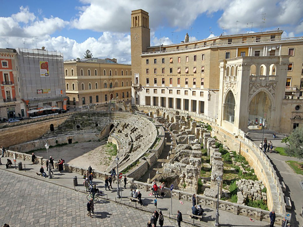
LECCE
|
|
Lecce
is located in the central-northern part of the Salentine plain, in the so-called "Tavoliere di Lecce": the lowland of Salento situated between the terraced uplands of the Murge to the north and the "serre salentine", to the south. Lecce is the easternmost provincial capital of the Italian peninsula.Read on ...The history of Lecce dates back to the "messapian era". Legend attributes the city's origin to Malennio Legend attributes the city's origin to Malennio in 1200 B.C., following the destruction of Troy. He is said to have introduced greek culture to the city, then called Sybar.In the 3rd century B.C., Rome conquered all of Salento and renamed the city of Sybar (modern Lecce) to Lupiae. Between the late Republican period and the early Imperial age, Lecce (ancient Lupiae) experienced significant urban expansion, becoming a walled city with a forum, a theater, an amphitheater, and a seaport: Porto Adriano, today's marina of San Cataldo. During the Neronian era, Lupiae (now Lecce) was evangelized by the patrician Publio Oronzio, who was converted to Christianity by Justus, a disciple of Saint Paul. Oronzio became the city's first bishop and martyr. During the medieval period, Lecce remained under the rule of the Eastern Roman Empire for five centuries. From the 6th century onwards, Lecce saw successive dominations by the Saracens, Byzantines, Lombards, Hungarians, and Slavs. The historical period between 1055 and 1463 is known as the "County of Lecce": a Norman-founded county of which Lecce was the capital, witnessing the rule of the Normans, Swabians, Angevins and Aragonese. From the mid-15th century, Lecce was incorporated into the Kingdom of Naples under Aragonese rule, during which it became an important commercial hub and a significant cultural center. Between the 16th and 17th centuries, the Salento region faced repeated threats from Turkish incursions, while the Spanish period saw a flourishing of civil and religious architecture in the city. In the year 1656, the population of the city of Lecce was decimated by an epidemic of plague and religious tradition tells that the epidemic ended thanks to a miracle obtained through the intercession of Saint Oronzo, who was subsequently proclaimed patron saint of the city, replacing the previous patron saint Irene. Between the 17th and 19th centuries, the people of Lecce, led by the local nobility, successfully resisted the restoration of Spanish rule and opposed various Austrian attempts to control the territory. Following the unification of Italy, particularly between 1895 and 1915, Lecce underwent significant urban expansion, with the construction of numerous public works and the development of new districts outside the city walls in neoclassical, neo-Moorish, and neo-Gothic styles. What to visit in Lecce: Lecce's historic center boasts an architectural structure rich in churches and palaces built in the Baroque style during the 17th century, using the characteristic "Lecce stone". The term "Lecce Baroque" identifies this unique 17th-century architectural style, characterized by the elaborate decoration of church and palace facades, developed during the Kingdom of Naples. Lecce's historic center was once surrounded by the "Mura Urbiche", a 16th-century defensive wall, partially replaced in the northwestern area by the "Bastione San Francesco". Access to Lecce was possible through four gates: Porta Napoli (1548), leading to Naples, the capital of the Kingdom; Porta Rudiae (1703), leading to the ancient Messapian settlement of Rudiae; Porta San Biagio (1774), opening towards Capo di Leuca; Porta San Martino, leading to the sea, which was demolished in the early 19th century. The defensive urban structure of medieval and Renaissance Lecce is also evidenced by two towers: "Torre del Parco" (Turris Prati Magni 15th century) located in the heart of the city, built on three levels and surrounded by a moat where bears—symbols of the Orsini del Balzo family—were once kept; and "Torre di Belloluogo" (14th century), a late Angevin military structure with a cylindrical tower surrounded by its original water-filled moat, situated at the opposite end of the city from Torre del Parco. Entering Lecce's historic center through "Porta Rudiae", one arrives at "Piazza del Duomo", the city's central square, featuring structures in the distinctive "Lecce baroque" style: the Cathedral of Santa Maria Assunta (the Duomo), the Bell Tower, the Episcope, and the Seminary Palace. Nearby, one can visit the "Roman Theater" from the Augustan era and the elegant "Piazza Sant'Oronzo", partially occupied by the "Roman Amphitheater" (1st-2nd century A.D.), where stands the "Column of Saint Oronzo", opposite which is the "Sedile", the former municipal headquarters. Piazza Sant'Oronzo also houses two significant Baroque religious landmarks: church of San Marco and church of Santa Maria della Grazia. Adjacent to Piazza Sant'Oronzo is "Castello Carlo V" (1539), a renaissance military structure commissioned by Emperor Charles V to replace an older medieval fortress. Nearby, Piazza Vittorio Emanuele II features numerous cafes and another baroque religious site, Santa Chiara Church. Lecce’s history has been deeply marked by successive foreign dominations—Norman, Angevin, Aragonese, and Spanish during the Counter-Reformation. he city’s religious heritage is reflected in its numerous churches, with over forty scattered throughout its streets and squares. Among them, three hold the status of minor basilicas: "Basilica of Santa Croce "(16th century), "Basilica of San Giovanni Battista al Rosario" (17th century) e "Basilica of San Domenico Savio" (20th century). Additionally, one of Lecce’s oldest churches, dating back to the Norman rule in the 12th century, is: the Church of Saints Niccolò and Cataldo. Lecce's religious heritage is further evident in its numerous convents and monasteries, including:: "Palazzo dei Celestini" (17th century), adjacent to the Basilica of Santa Croce, "Monastery of the Theatines" (16th century), next to the Church of Saint Irene, "Carmelite Monastery" (16th century), next to the Church of the Carmine, "Dominican Convent of Saint San Giovanni D'Aymo" (14th century), where its "Cloister" holds a particularly important place in the artistic-cultural panorama of Salento, "Palazzo del Collegio dei Gesuiti" (16th century), "Convento degli Agostiniani" (17th century) and "Ex Conservatorio di Sant'Anna" (17th century), next to the Church of Saint Anna. Inside the city of Lecce, in the garden of Palazzo Guarini in via Palmieri, an example of Messapian funerary architecture can be visited: the "Ipogeo Palmieri"; furthermore, remains of the ancient Messapian centre of Rudiae are present on the road to San Pietro in Lama, the "Archaeological Park of Rudiae". The Lecce area offers a great gastronomic variety of local dishes that use the typical agricultural products of the Apulian lands: calzone fritto, rustico leccese, puccia, pizzi leccesi, pittule, taralli leccesi, frisa, pitta di patate, fave e cicorie, ciceri e tria, orecchiette al sugo alla ricotte forte, taieddhra leccese, sagne n’cannulate, turcinieddhi, polpo alla pignata, pasticciotto, purceddhruzzi, mustazzoli e dolci di pasta di mandorla. Finally, at the end of a meal enjoyed in one of the restaurants in the city centre, in the Porta San Biagio and Piazzetta Santa Chiara area, it is a must to taste the exclusive "caffè leccese". Notable events in Lecce include: Feast of Saints patroni Oronzo, Giusto e Fortunato, the religious festival in honor of the patron saints of the city of Lecce lasting three days (from 24 to 26 August); and Nativity and Puppet Fair, ancient popular market of various goods related to nativity scenes which takes place from 8 to 24 December in the historic centre of Lecce. |
|
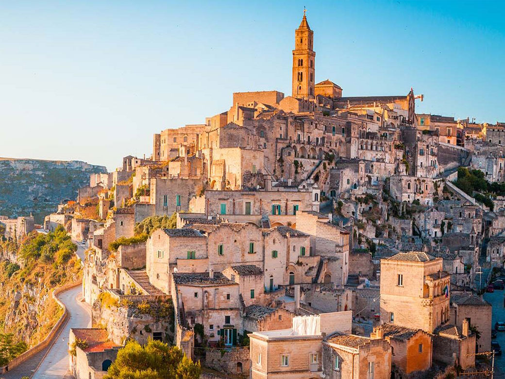
MATERA
|
|
|
Matera
is located on the extension of the Murge plateau to the east and the Bradanic depression (crossed by the Bradano river) to the west. The city of Matera is in the eastern part of the Basilicata region, bordering the southwestern part of metropolitan city of Bari (with the municipalities of Altamura, Gravina in Puglia and Santeramo in Colle) and the northwesternmost part of the province of Taranto (with the municipalities Ginosa and Laterza). Matera is known worldwide for the "Sassi", making it one of the oldest continuously inhabited cities in the world. The "Sassi" districts were recognized as a UNESCO World Heritage Site in 1993, the first site in southern Italy to receive such global recognition. Read on ...The origins of Matera date back to the Paleolithic era, as evidenced by the discovery of various objects from that time in the caves along the Matera ravines, proving the presence of hunter groups. During the Neolithic age, stable settlements began to form, as indicated by the remains of several fortified villages from that period on the Murgia Timone. The Metal Age saw the birth of Matera's first urban nucleus (the current Civita) on the right bank of the Gravina.Matera’s origins are also linked to Greek presence in the classical era when it had close relations with the Magna Graecia colonies on the southern coast. During the Roman period, Matera served as a passage and supply center. In the medieval period, control over Matera was contested between the Lombards, Saracens, and Byzantines until it experienced a long period of peace under Norman rule from the 11th century onwards. In the modern era, Matera transitioned from Aragonese rule in the 16th century to Spanish rule in the 18th century, becoming the capital of Basilicata and the seat of the Royal Audience. Following 1860, Matera and all of Basilicata became a center of post-unification brigandage. In contemporary times, the people of Matera were particularly active in the anti-fascist and anti-Nazi struggle.In 1945, Matera witnessed the first popular uprisings demanding the allocation of uncultivated lands in the south. In the post-war years, the "question of the Sassi of Matera" gained national political attention, ultimately leading to the 1952 law mandating the evacuation of the Sassi and the construction of new residential districts. In 1986, a new national law funded the restoration of the ancient Sassi districts, and in 1993, the city was declared a UNESCO World Heritage Site. Finally, in 2019, Matera was designated as the "European Capital of Culture". What to visit in Matera: the historic center of Matera coincides with the "Sassi" territory. The "Sassi di Matera" consist of buildings and rock-hewn architecture carved into the rock along the Matera ravine, divided into two valleys: the Sasso Barisano (named for its orientation towards Bari), in the northwest, featuring sculpted portals and underground structures, and the Sasso Caveoso (named for the numerous caves), in the south, resembling a theatrical cavea. The rocky spur that separates the two Sassi hosts Civita, the oldest inhabited part, enclosed within the former city walls, where the Cathedral and noble palaces are located. Matera is also at the heart of the "Matera Murgia Park" which includes the Gravina of Matera, rock churches scattered along the ravine slopes, and the Murgia plateau. The Tramontano Castle (16th century), in Aragonese style, stands on the Lapillo hill overlooking the historic center, while the Metellana Tower, is located in the Sasso Barisano, constitute the remains of the military architectures in defense of the "Civita" . Matera is one of the most ancient and best-preserved examples of bio-architecture in the world, featuring a complex water collection system (cisterns and "palombari") carved into limestone to address water supply challenges while ensuring safety. This network of underground cisterns forms the famous "Underground Matera," with the "Palombaro Lungo" (19th century): a huge underground cistern, below Piazza Vittorio Veneto, into which rainwater and spring water from the hills of La Nera, Lapillo and Macamarda flow together. Matera's deep religious heritage is evidenced by its Cathedral, in Apulian Romanesque style, built in the 13th century on the highest spur of the Civita, and by numerous religious structures within the city walls (Church of San Pietro Caveoso, 13th century; Church of San Francesco d'Assisi, 13th century; Church of San Domenico, 13th century; Cloister of Sant'Agostino, 16th century;Church of Santa Chiara, 17th century;Church of Santa Lucia and Agata alla Fontana, 18th century; Church of San Francesco da Paola, 18th century; Church of Purgatorio, 18th century), outside the city walls (Church of San Giovanni Battista, 12th century; Sanctuary of Madonna di Picciano, 13th century; Santuario della Madonna della Palomba, 16th century) and the rock churches present in the city and along the Gravine of Murgia Materana Park (there are around 150 small churches dug into the rock, among the most important Santa Lucia alle Malve, Convicinio of Sant'Antonio, Santa Maria di Idris, Santa Barbara, Madonna delle Virtù and San Nicola dei Greci, San Pietro Barisano, Crypt of the Original Sin). At the top of the city centre, the Civita, the hub of the old city, are the residential buildings of the noble families who dominated the centuries-old history of Matera: Palazzo Porcari, home of the noble Matera Porcari family of Roman origins, located in Piazza San Francesco; Palazzo Bernardini, dominates the Sasso Caveoso since the 15th century; Palazzo Malvinni-Malvezzi, in Piazza Duomo, dating back to the 15th century; Palazzo di Castro Vetere, probably belonged to the Palmieri family at the head of the bishopric of Matera between the end of the 14th and the beginning of the 16th century; Palazzo del Sedile, built in the 16th century in the central Piazza Sedile and currently home to the city's Music Conservatory; Palazzo Venusio, built in via S. Potito in the 16th century; Palazzo Lanfranchi, built in the 17th century and currently houses the premises of the National Museum of Medieval and Modern Art of Basilicata; Palazzo dell'Annunziata, located in Piazza Vittorio Veneto, Palazzo Bronzini, located on the corner between Piazza del Sedile and Via Duomo, Palazzo Gattini, located in Piazza Duomo, Palazzo Ridola, in Via Duomo, they are all noble residences built in the 18th century. Finally, Palazzo Pomarici deserves a special mention, also known as “The palace of a hundred rooms”, which stands on the edge of Civita and whose construction dates back to the 17th century. It covers an area of approximately 3000 m2 and houses the premises of the Museum of Contemporary Sculpture of Matera. Matera hosts numerous thematic museums: Casa Noha, FAI property, place from which to begin your visit to the city of Matera, retracing its history thanks to an innovative communication project; Domenico Ridola National Archaeological Museum, it preserves archaeological remains from the prehistoric age of indigenous cultures and populations (Enotri and Lucani); Museum-Laboratory of Peasant Civilization, preserves objects and tools of the ancient crafts of the Sassi; Museo Diocesano, where works dating between the 11th and 19th centuries are exhibited; already mentioned National Museum of Medieval and Modern Art of Basilicata, hosted inside the Palazzo Lanfranchi, e il MUSMA, hosted inside Palazzo Pomarici. Finally, you cannot leave the city of Matera without visiting the Casagrotta of Vico Solitario: an ancient house dug into the rock typically furnished located in the Sasso Caveoso, which allows us to understand the habits and customs of the inhabitants of the ancient Sassi districts of Matera. The events which feature the city of Matera have an exquisitely religious character: the "Mater Sacra Easter" a Passion of Christ reenactment in the suggestive environment offered by the Rione Pietroso, close to the Sassi, starting from Holy Thursday and culminating in the unmissable Via Crucis, which starts from Piazza del Sasso Caveoso and reaches the Madonna de Idris Rock Church. The Sassi of Matera, with their affinity to the landscape of Palestine, constituted the ideal setting for the cinematic representation of the story of the Passion of Christ. Similarly to Easter, the religious celebration of Christmas culminates in the representation of the "Living Nativity Scene" in Matera , which brings to mind the original setting of the birth of Jesus Christ in the stations and locations within the city of Sassi, thus offering moments rich in mystical atmosphere and religious involvement, both for the inhabitants and for the many tourists of the Christmas period. "Festa della Madonna della Bruna" is celebrated in the city of Matera every year on July 2nd since 1389, when it was established by Pope Urban VI as the "Feast of the Visitation". Even today the celebrations culminate with the parade of the triumphal papier-mâché float carrying the Madonna della Bruna, which at the end of the procession is stormed by the people of Matera to grab a piece of it as a wish for good luck and prosperity. About a month later, on August 1st, in the peripheral village of La Martella, the "Sagra della Crapiata" takes place, considered the popular festival of the Matera summer and which was born with the intent of celebrating the good harvest, which culminates in the preparation of one of the typical dishes of Matera.: Crapiata, based on legumes and cereals, cooked slowly in large pots assisted by the women of Matera and many visitors. On this occasion, the city of Matera fills with stalls, folk music concerts, in a banquet that unites residents and tourists. The Matera summer ends with the celebration of the religious festival in honor of the patron saint Sant’ Eustachio on September 20th of each year, which begins with the celebration of Holy Mass in the Cathedral, followed by the procession with the statue of the saint along the city streets, to conclude in the evening with a fireworks display, in the splendid setting in front of the Sassi. The city of Matera is characterized, like nearby Puglia and all of southern Italy, by culinary products closely linked to the agricultural tradition of its territory: first courses made with local and seasonal vegetables (Crapiata, Materan-style orecchiette, Fava beans with chicory, Pasta with cruschi peppers), locally farmed meat dishes (Pignata, Gnimmeredd) and to complete the lunch, the typical local tradition and festive desserts (Strazzate, Panaredda, Cartellate). The absolute most characteristic product of Matera's gastronomy is "Pane di Matera" (Matera Bread), obtained from the traditional processing of durum wheat flour, water, salt, yeast carried out at home in the past and cooked in public wood-fired ovens, where each family marked their own loaves of bread with a distinctive stamp during cooking intended for home use for several days. In 2008, "Pane di Matera" (Matera Bread) obtained the protection of the IGP (Protected Geographical Indication) status. |